The following article has been converted to HTML format.

SIGNAL, AUGUST 1998, Official Publication of AFCEA
Navy Explores European Offerings
Of Airspace Datalink Technologies
Commercial off-the-shelf products hold promise,
but additional, extensive testing is still required.
Crowded skies and a deluge of air accidents are driving all sectors of the world's aviation community to pursue efficient and effective ways to meet increasing demand while boosting safety. Commercial carriers, cargo airlines and the military are developing alternatives to current radar-based tracking systems. While emerging options will not replace today's air traffic control systems, they will facilitate mass modernization of free flight, where pilots communicate directly with each other to plan their routes.
The military is closely scrutinizing developments in the commercial aviation world and experimenting with commercial off-the-shelf products, searching for cost-effective alternatives that also meet the need for interoperability between the systems of all types of aircraft. Several aircraft-to-aircraft communications systems packages are being improved, including a transponder first developed in Sweden.
The Swedish Civil Aviation Administration, in cooperation with private industry, continues to expand testing of a system that promises to benefit future communication, navigation and surveillance/air traffic management scenarios (SIGNAL, February 1995, page 14).
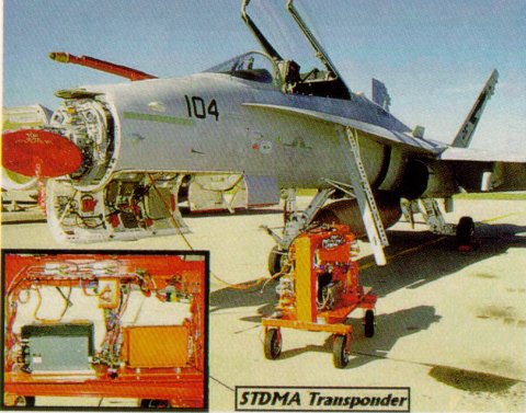
The global navigation satellite system (GNSS) transponder is among several components of the cellular. communication, navigation and surveillance system. It consists of a GNSS receiver, a communication processor and a very high frequency (VHF) transceiver. The receiver generates position and time data. Position information is used to navigate and broadcast automatic dependent surveillance data on the datalink. The datalink uses a self-organizing time division multiple access (STDMA) scheme, also known as a VHF datalink Mode 4. The two-way link is capable of handling time-critical information in well-defined time slots for air-to-air, air-to-ground and ground-to-ground communication.
The end system architecture includes a combination of the VHF STDMA datalink for line-of-sight communications and satellite communications for long-range transmissions. Because the transponder is capable of managing multiple channels simultaneously, communication, navigation and surveillance services used during a flight can also be employed on the ground.
The equipment is manufactured by Swedish Space Corporation, Solna, Sweden; SAAB Dynamics, Linköping, Sweden; and GP&C Global Support, Billund, Denmark.
Under the Defense Department's federal aviation surveillance system for test and evaluation ranges (FASSTER) program, the U.S. Navy conducted a test flight of the transponder onboard an F/A-18C Hornet aircraft. The program investigates evolving civil aviation surveillance datalink/protocol for Defense Department and Navy applications. These applications would include an interoperable surveillance scheme that might satisfy requirements of both military and the future national airspace structure architecture including automatic dependent surveillance, according to Richard Shin, electronics engineer and project manager for FASSTER, Naval Air Warfare Center Aircraft Division, Patuxent River, Maryland. The applications would also meet the requirements of Defense Department and Navy-specific test range data collection efforts involving various aircraft with varying dynamic performances, he says. In addition, the program uses the surveillance data to test automated collision alert algorithm processes.
The GNSS transponder-equipped F/A-18C flight test was the project's final evaluation phase. The test took place at the Patuxent River Naval Air Test Center, Maryland, and included the radio frequency transmission of global positioning system (GPS)-derived positioning information and inertial navigation system output data from the Hornet. It used a 19.2-kilobit-per-second

The U.S. Navy Is exploring global positioning and communication technologies developed In Sweden and Denmark. In a recent flight, a global navigation satellite system transponder was tested for use on an F/A-18C Hornet.
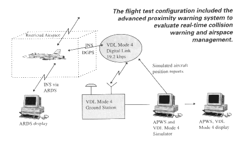
STDMA datalink providing 75 slots per second. Positioning information was downlinked from the aircraft at 1 hertz as part of the standard synchronization bursts used in STDMA, while the inertial navigation system data was downlinked at 5 hertz in the form of user-specific data. Test equipment also included a stationary van transmitting STDMA synchronization bursts at 0.5 hertz and uplink transmissions of groundstation synchronization bursts, time strobes and differential GPS corrections.
The datalink was a component of the overall test, according to a report prepared for the Navy by Project Management Enterprises Incorporated, Bethesda, Maryland. From an operational standpoint, the more significant element was the delivery of real-time positioning and navigation data to a ground-based processor used for displaying aircraft position and probing for future safety threats. Simulated aircraft positioning reports could be injected to test this element of the system, the report says.
The 90-minute test flight was divided into low dynamics of less than 3 g's, medium dynamics of between 3 and 4 g's, and high dynamics of more than 4 g's. Each level included climbs, descents, turns and half-loop maneuvers.

During the low-dynamics section of the test, the digital link performed without interruption. GPS acquisition was continuous; tracking functioned smoothly; and the display with VHF datalink Mode 4 position exhibited little or no difference from the reference aircraft range data system display, Gunnar Frisk, system engineer, Swedish Civil Aviation Administration, reports.
In the mid-dynamics stage, GPS acquisition was lost intermittently. This occurred during maneuvers with loads of 3.5 to 4 g's and particularly during half loops when the antenna was pointing down, away from satellites. The same results occurred during high-dynamics tests, although during the final 10 minutes of continuous high dynamics at a maximum load of 6.7 g's, GPS was lost entirely. However, the digital link was functioning throughout both the medium- and high-dynamics sections of the test, Frisk says.
The medium- and high-dynamics test results were expected because of the physical positioning of the antenna on the fuselage. In addition, the VHF datalink Mode 4 prototype transponder used in the tests as well as the receiver were exclusively commercial off-the-shelf products that are not designed for high-fidelity aircraft such as the Hornet, he says.
The advanced proximity warning system (APWS) was developed within FASSTER to test and evaluate realtime collision warning and airspace management for monitoring by air traffic control. The system is currently ground based but could be connected to a cockpit display in an aircraft to improve a pilot's situational awareness. To check APWS during the test flight, several close encounters between the test aircraft and a simulated aircraft were conducted. During the flight, the APWS display provided air traffic control advisory information, including collision alerts.
According to Prasad Nair, president, Project Management Enterprises Incorporated, the test flight was a successful demonstration of the use of a commercially developed aviation datalink in which internal GPS reporting messages were supplemented with inertial navigation system data. The information downlinked from the Hornet provided the ground controller with real-time data about the progress of the aircraft. In addition, the use of a simu