The following article has been converted to HTML format.

Avionics/August 1992
The Chicago Trials
A GPS Evaluation
FAA, ARINC, United Airlines and the City of Chicago explore differential GPS for airport ground surveillance.
by Damon C. Hart
The potential use of satellites to support civil aviation navigation has been a hot topic for many years. Until recently, however, costs and technological problems have made satellite navigation impractical and unavailable.
The satellite arrays to support practical satellite navigation include the Department of Defense’s (DOT’s) Navstar Global Positioning System (GPS) and similar Soviet GLONASS system.
There have also been considerable advances in the development of satellite navigation receivers. Digital avionics technology has made it possible to develop products with more capabilities and better performance at reasonable costs. Many companies already offer GPS sensors and receivers.
Satellite navigation presents an opportunity for standardized civil aviation operations anywhere in the world using a common receiver. It can also improve safety and service flexibility, increase capacity and lower operating costs. It also offers the potential for new navigation, landing and surface surveillance services not supported by existing systems.
FAA has formally recognized the role of satellites In support of future navigation systems. The overall objectives. described in the FAA Satellite Navigation Program Plan, FY 92-97, is use of satellite navigation for all civil aviation navigation needs: "The primary stand-alone navigation system of the 21st Century will be provided by a Global Navigation Satellite System (GNSS)." Furthermore, the plan continues, "satellite navigation systems could lead to the phaseout of existing National Airspace System (NAS) ground equipment while maintaining or improving existing levels of service."
GNSS will evolve from the current GPS and GLONASS systems now under development and will use "other satellite systems as they become available," the plan states. At the moment, however, GPS is the cornerstone for all announced GNSS applications.
When fully developed, GNSS has the potential to become a standard, worldwide navigation utility for air carriers and private aircraft. If the goals are achieved, GNSS may become as widespread and as important to the aerospace industry as fuel and communications.
The Chicago Trials
United Airlines and the City of Chicago Department of Aviation last year agreed to begin exploring development of GPS applications in civil aviation. Some expected benefits include shorter routes on long oceanic flights, more fuel-efficient routes on domestic flights, instrument approaches at airports having none today, ground tracking and guidance for aircraft and airport vehicles, improved snow clearance operations and guidance for emergency vehicles in low visibility.

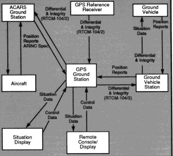
Schematic of differential GPS system under evaluation at Chicago O’Hare.

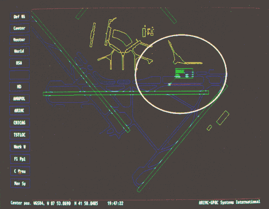
Situation display shows airport vehicle (represented by white box with red line) being tracked using differential GPS data Red vector line indicates direction and speed. (white circle added for clarity.)
GPS Overview
Navstar Global Positioning System (GPS) is a satellite navigation system developed and operated by the U.S. Department of Defense, which, when complete, will consist of a constellation of 21 satellites. The satellites are configured In six orbital planes (at a height of 11,000 miles) with three or four satellites each. There will also be three operational spares.
GPS provides highly accurate position and velocity Information in three dimensions, as well as precise rime, to users everywhere in the world 24 hours a day. The original, principal purpose of GPS was as a highly precise military navigation and positioning system.
GPS positions are calculated using the basic principle of triangulation. Instead of the more traditional approach of simply measuring the angles of the satellites' signals then plotting them to an intersection point, GPS signals are used to establish the amount of time that has elapsed from the moment the signal is sent until the moment it is received. A highly accurate time source is essential to the operation of the system.
Each satellite weighs about 2,000 pounds and has an expected life of about eight years. The GPS satellites are manufactured by Rockwell International. When fully deployed in 1993, a minimum of four satellites will always be in view by a user anywhere on earth.
Position fixes of considerable accuracy are possible. Civil aviation uses of GPS are also possible and practical. Horizontal position accuracy of 100 meters and vertical accuracy of 150 meters is possible with a civilian GPS receiver. The principal causes of error in GPS positions are distortion caused by the ionosphere; signal reflection, where the GPS receiver senses the same signal more than once; and Selective Availability (SA), a deliberate error introduced by the DOD for national security reasons.
The Russian GLONASS satellite constellation is similar in function and could be operational in 1995. GPS receivers that can access both GPS and GLONASS are technically possible. These could be very useful, due to improved satellite geometry from twice the number of satellites.
FAA, United, Chicago and Aeronautical Radio, Inc. (ARINC), are jointly conducting engineering tests of GPS technologies at Chicago's O'Hare airport under a program that has become known as the Chicago Trials.
These tests will focus on a variety of GPS surface surveillance Issues, Including low-visibility taxiing, operational control and surveillance of ground vehicles and runway incursion prevention.
The goals are to demonstrate and test differential GPS (dGPS) technology in a large, complex airport environment and provide a showcase for GPS technology. Applications Include airline and airport operations, air traffic control and safety enhancements.
Project leaders also want to assure that there are no adverse Impacts on air traffic control, airport or airline operations. In addition, they will conduct an engineering evaluation of multi-vendor equipment configurations and refine formats and protocols for the transmission and use of dGPS data among reference stations, control sites and moving vehicles.
Phase 1 of the project (which began this summer) will track one ground vehicle and Phase 2 will track six ground vehicles. In Phase 3. the program will track a "pseudo-aircraft" (a truck with GPS and ACARS) using ACARS. The final phase will track real aircraft using ACARS and will simultaneously track ground vehicles. The duration of the demonstration may be as long as one year and will establish an overall technical baseline for comparison purposes.
The trials are "an experiment to test different equipment and compare usefulness, accuracies, and ability to Interconnect In a common system," said Ray Hoffelt, O’Hare airport operations supervisor. "They can help us start to compile a sort of Consumer Reports evaluation of GPS equipment and software."
The City of Chicago, which Is providing airport vehicles and is coordinating the use of airport facilities, is testing the feasibility of tracking emergency and snow removal vehicles on the airport grounds.
From ARINC’s perspective, the trials will "establish a dGPS baseline and Interface specifications to permit different vendor solutions to be compared and perhaps even interconnected, on a common playing field," said Jim Kendrick, ARINC program manager for GNSS market development.
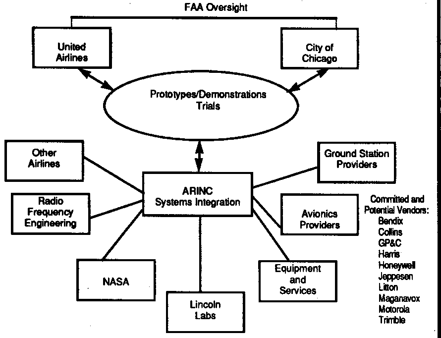
ARINC is performing system design Integration, test direction, reporting and data link communications and Is coordinating activities of equipment vendors. ARINC's goal is to confirm the operational usefulness of dGPS technology in a real life, multi-vendor equipment configuration. David Taylor, ARINC's director of air traffic service planning, also hopes the trials will "provide industry with the required data link that will take advantage of the more than 3,000 ACARS equipped aircraft."
The O'Hare Terminal 2 Observation Deck houses the ground operations center In an area overlooking the airport ramp, taxiways and runways. Equipment Includes a GPS ground station and GPS reference antenna. dGPS-derived position collections are transmitted to each vehicle being monitored. Along with their own GPS sensor data, these vehicles will use the dGPS data to report their precise position back to the operations center.
ARINC installed the ground differential GPS reference station, ground control displays and data link transmitter-receiver. Several airport vehicles and airline aircraft were fitted with GPS receivers, data link radios and map display units. During the trials, vehicle drivers and aircraft pilots will use this GPS installation to explore the practicality of navigating on the airport surface. Controllers will use the system to monitor the locations of aircraft and vehicles at the airport.
Communications facilities include the ground mobile data radio (GMDR) for ground-vehicle positioning and ACARS for aircraft (and pseudo-aircraft) vehicle positioning.
United Airlines is providing aircraft, avionics and airline ground vehicles and initially expects the trials to test the tracking of baggage, catering and fuel vehicles. Later, the airline hopes to use the installed system to navigate its aircraft between the gate and the taxiway.
Teamwork is "one of the most Important factors at work In the trials and one of the biggest challenges to the future success of all GPS applications," said Ed Phillips of FAA, which is overseeing the trials. Phillips, FAA's Great Lakes Regional Administrator, added: "FAA needs to work closely with the airlines and the manufacturers to develop a workable cooperative system out of the GPS technology available today."
For GPS applications to be practical, they must be universally available. An aircraft using GPS to depart from Chicago this afternoon must e able to use the same on-board system for landing and taxiing in Asia or Europe tomorrow. Multiple vendors' equipment must successfully work together in such areas as data link message formats. Internationally accepted standards are needed. Maps and navigation systems of different countries must all conform to common standards.
Several vendors of GPS receivers and navigation, displays, computers and communications products provided equipment and software (see box). Other vendors will be invited to demonstrate and test products, including GPS sensors (ground and airborne), GPS reference stations, situation displays and software and data links.

Beyond Chicago
Chicago is not the first effort to show the usefulness of GPS for navigation and situational awareness. There have been others, including:
NASA/Honeywell, Fall 1990, Wallops Island: demonstration of dGPS/INS final approach;
FAA/DSDC, Summer 1991, Manchester, N.H.; demonstration of GPS ground surveillance;
GP&C International, in progress, Gothenburg/Landvetter, Sweden: trials of surface surveillance:
Trimble/Morrison/Harris, 1991, Melbourne: surface surveillance;
FAA/Honeywell/NWA, Fall 1991, FAA Technical Center flight tests of final approach;
Trimble/Petroleum Helicopters Inc., Gulf of Mexico, DGPS approach to helicopter platforms.
What differentiates the tests at Chicago is that they are real world. Other efforts have suffered from one or more reality problems, such as an airport with only one runway, a tower with only one man and one microphone, no radar, no significant airport traffic, only one vehicle tested.
Chicago, on the other hand, is as real-world as it gets. It Is an Interesting, nontrivial, busy place with an unpredictable environment. At Chicago, only one runway is free of any crossing runways, a lot of construction Is always underway, there is no unobstructed data link on the airport, multi-path (GPS signal reflection) is a significant problem and bad weather is frequent. In short, it has the worst conditions In the world. If GPS applications work in Chicago, they apply anywhere.
The Chicago Trials, then, could be a first step In validation of GPS for civil aviation. Additional trials at other locations will happen soon that will explore other phases of flight (for example, approach and departure navigation) and the usefulness of DGPS technology. Participants at O'Hare have a much bigger vision of GNSS for the future.
Cities and airport authorities see GNSS as a way to achieve better airport surface situational awareness at a reasonable cost, including:
Positive Identification and positioning of aircraft and ground vehicles, 0 Monitoring and warning of runway incursions,
Situational display presentation of snow removal equipment position, 0 Aid to taxiing aircraft in low visibility, 0 Distance remaining on runway for landings and departures,
Aid to identify ILS critical areas, clear zones and holding positions,
Location of emergencies in low visibility,
TCA alerts,
Aircraft assistance through VFR corridors,
Better use of runways in reduced visibility conditions, and
Surveillance for multiple and parallel runways.
"The FAA is just as interested in the application of dGPS to general aviation and rotorcraft," said FAA’s Phillips. "We want to explore technologies that will bring down the cost of flying for everyone, from commercial carriers to private pilots."
Airlines see GNSS as a way to reduce the likelihood of runway incursions, improve safety and performance in all phases of flight and reduce flight time and fuel consumption (in concert with ADS). In addition, airlines see GNSS providing the capability for precision instrument approaches at an airports, improved airport ground operations and improved departure guidance.
GNSS Applications
GNSS is still in its infancy: the GPS and GLONASS satellite arrays are incomplete. Yet It has the potential for providing an Internationally standard, economical method to get improved and highly accurate position Information for all phases of flight operations, including:
Improved position information in oceanic, en-route and terminal areas of flight. This will allow reduced separation between aircraft and random routing of aircraft without compromising safety. More aircraft can use optimal routes, with significant fuel savings.
Better access to airports. The goal Is to provide highly accurate aircraft position Information to support guidance for all airports on all runways In either direction for both arrivals and departures. Standardized Instrument approaches based on GNSS decreases pilot training and certification costs. They result In Improved access to thousands of airports and runways used by commuters and general aviation aircraft. Curved approaches to ILS-equipped airports also are possible.
Improved standard instrument departures. Departure navigation In very low visibility provides guidance for lining up on the runway, take-off roll, standard instrument departures, Initial climb-out, noise abatement and climb to en-route navigation.
Improved ground control for accurate aircraft and vehicle positions. This permits low-visibility taxiing operations, airport emergency vehicle operations, improved runway incursion prevention and coordination of airline ramp activities.
Because of the critical nature of navigation and position information to civil aviation, the development of GPS applications in these areas will undoubtedly proceed cautiously. Issues of safety, reliability and proven performance will be paramount. Although there are GPS navigation avionics already installed in general aviation aircraft, their current use is limited to secondary navigation. These installations typically support en-route navigation. None has been certified for use as the principal navigation aid in IFR situations.
Before GNSS can achieve Its goals, several airspace and airport Infrastructure issues must be addressed including definition of GNSS approach, departure and missed-approach routes, aircraft holding stacks, supporting radar coverage for routes and stacks, etc. Issues of satellite signal Integrity and accuracy must be resolved in any major civil aviation application of GNSS.
GNSS has a lot of potential, but there Is much to learn and many issues to resolve before it can achieve its goals. The work in Chicago is an important first step.
Equipment
The following is a hst of equipment being used in the Chicago Trials.
GP$ Reference Station (Phase l):
Magnavox 4200 GPS sensors with special ground reference software frorn GP&C
NEC 19-inch color situation displays, Including Compaq 486 controller and special GP&C software
PC/486 ground station controller
Motorola VHF transceiver
GP&C GPS transponder and controller GPS Reference Station (Phase 2):
Magnavox 4200 GPS sensors with special ground reference software from GP&C
NEC 19-inch color situation displays, including Compaq 486 controller and special GP&C software
SUN ground station controller
Motorola VHF transceiver
GP&C GPS transponder and controller
GPS Reference Station (Mases 3&4):
Magnavox 4200 GPS sensors with ground reference software from GP&C
NEC 19-inch color situation displays, including Compaq 486 controller and special GP&C software
SUN ground station controller
ARINC ACARS Ground Station, lncludlng Wulfsburg Transceiver and Viatek GSC- 101, PD128 antenna
Ground Vehicles (Phases 1&2):
Magnavox 4200 GPS sensors wlth mobile unit software from GP&C
Cornpaq/386 laptop controller
Motorola VHF transceiver
GP&C GPS transponder and controller
Ashtech Ranger GPS receiver
Pseudo-airplane and airplane (Phases 3&4):
Litton GPS sensor unit with controller
Teledyne 724B ACARS management unit
Honeywell ACARS control unit
Collins ACARS 716 transceiver
Ashtech M-XII GPS receivers
Damon Hart is a consultant in the avionics industry
Press clip as MS WORD dokument